With the summer warmth fading we decided we’d make one last hike for the season to take advantage of the leaves changing colour in fall. We decided to tackle the ‘100 Mile Wilderness’ – a hike spanning the final 100 miles of the famed Appalachian Trail (AT), and what many regard as the finest and most remote section of the entire AT.
This involved driving over 4,000 kilometres from Arizona’s Grand Canyon to the trailhead in northern Maine – with this epic distance of what felt like non-stop driving for 4 days giving us pause to think that the AT hikers had walked nearly this same distance: 3,500km.
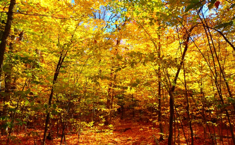
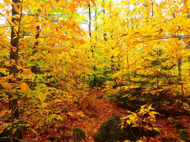
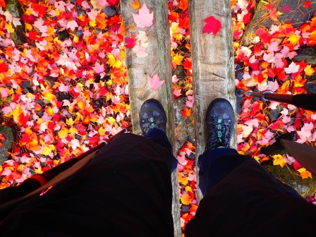
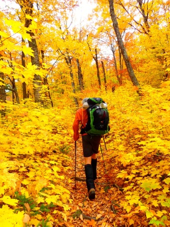
As we drove through New England, we feasted our eyes on the incredible palette of reds, pinks, oranges and yellows that blanketed the landscape around us. Every twist and turn of the road seemed to bring an explosion of colour that outdid the last.

Day 1: Abol bridge – Hurd Brook Lean-To (3.5 miles)
We had arranged to leave our van with Phil, the owner of the 100 Mile Wilderness Camp in Monson, and to pay him to shuttle us up to Abol Bridge where we planned to start (contact details for Phil below). Phil showed us around the cabins that he was in the process of fixing up – we had tentatively booked to stay there when we got back from the hike, but the lack of rain in Maine (ha!) had depleted his water reserves, so we quietly decided that we might look further afield for somewhere offering hot showers…
After lunch and a repack of our bags, we were bundled into Phil’s car for the 2-hour drive up north, with a quick stop off to check out a dam across the Penobscot River – famed for white water rafting. Phil gave us a load of tips for the trail, and regaled us with tales of his bodybuilding, weightlifting and hiking prowess as we went – and told us we were lucky to have caught the tail end of ‘peak foliage’ (the first of our new leaf-based vocab) as the low rainfall had threatened to stifle the annual event.
We arrived at Abol Bridge around 5pm and set off immediately, as the days were getting increasingly short and we only had little more than an hour before dark.
We felt as though a royal carpet had been laid out for us across the path, with the fallen leaves forming a multi-coloured mosaic on the trail before us that made our brains tingle with delight. We reached the Hurd Brook Lean-to after dark, having walked the last half-hour with our dimly-lit headtorches (with Angie pining for her AyUp that she’d left back in Australia in preference for the very light-weight (in multiple senses) Petzl e-lite) to find a campfire already burning. There we met Daniel, the first of the AT through hikers we were to meet on the trail. We enjoyed a great night hearing about Daniel’s epic trip and grilling him on the best and hardest parts, and how he generated the grit to keep walking for 7 months straight.
Day 2: Hurd Brook Lean-To – beyond Wadleigh Stream Lean-to (18 miles)
We woke to find that mice had eaten through our dry bag (that had, mind you, been suspended from the roof, with a plastic plate tied onto the rope halfway down so that the mice couldn’t just climb down the rope…), and helped itself to all our salted cashews…

We had a leisurely start, having breakfast at the shelter and starting walking around 9am. It was a pretty flat day of walking, although muddy a lot of the way with the famed slippery, wet roots to navigate. We rounded Rainbow Lake with a long and beautiful traverse and stopped for lunch on it’s shores, where we chatted to a couple of through-hikers, getting the low-down on life on the trail. One fellow had taken 10 months, and espoused the virtues of going slow – although admittedly, it sounded as though a large factor was that he would head to town for a resupply around every 4 days and would often stay a night or two with much imbibing taking place with fellow hikers. We found this to be a similar story with a few other AT hikers we met, although we certainly weren’t going to criticize as who knows how we would feel after hiking for so long!
We continued past Nahmakanta Lake to just beyond the Wadleigh Stream Lean-to (where the stream that normally provided water was dry, thanks to the lack of rain) to a makeshift campsite on the shore of the Nahmakanta Lake. After a quick, chilly swim in the lake, we set up our tent just as it began to rain and get dark, and cooked a quick but tasty meal of cous-cous, TVP and rehydrated veg (our current staple…) before turning in.
Day 3: Beyond Wadleigh Stream Lean-to – Antler’s Campsite (13 miles)
We tag-teamed today with two American ladies who were out walking with their dog, walking past the well-equipped State Campsite on the southern shore of Nahmakanta Lake before heading over Potaywadjo Ridge. This has pretty minimal elevation gain, but still was a good puff to get up and over. We went past Pemadumcook Lake and the nearby lean-to, dodging through mud bogs and trying to not twist ankles on the slippery roots.
We arrived at Antler’s Campsite before 3pm, and Angie insisted on going ‘just for a look’, before proclaiming that it was so beautiful there, that we should pull up stumps and enjoy the views, serenity and a campfire there. The campsite is built on a narrow isthmus on the Lower Jo-Mary Lake, and surrounded on three sides by the water. The lake is large and pristine, with the orange and red trees ringing its far shores. We were ahead of our planned schedule by that point, and Jonno was admirably successful in suppressing his natural desire to go as far and hard as possible 🙂
We scoured the beach for driftwood and got a fire going, set up our tent, and tucked into a dinner of mashed potatoes with the standard TVP and veggies before an early night.

Day 4: Antler’s Campsite – Logan Brook Lean-to (20 miles)
After the shorter day yesterday – and long night’s sleep, we got up early to set off.
Jonno – who’s blood sugar levels seem to be consistently stable no matter what he has or hasn’t eaten – started out immediately, planning to have breakfast after an hour or so, while Angie sat by the lake to enjoy the views over breakfast and get some fuel into her belly.

We both really enjoyed the 1.5 hours of solo hiking in the morning and chance to collect thoughts and enjoy the beautiful views along the Cooper Brook, before meeting up at the Jo-Mary road crossing a few miles along.
From there, we started a steady eight miles of uphill towards Little Boardman Mountain (approx 2,000 feet high), before dropping back down to the Pleasant River. We then continued our ascent up White Cap Mountain with some very steep uphill sections and big steps up large rocks and tree roots. We stopped around 1250 feet short of the summit at the Logan Brook Lean-to before dark – and mindful of our first night’s experiences with the noisy and hungry mice, set our tent up nearby. We were soon met by Matt, a chatty New Yorker, who recounted tales of his adventures in the Adironack Mountains, before calling it a night.
Day 5: Logan Brook Lean-to – Chairback Gap Lean-to (17 miles)
We woke up early to find our legs stiff after the previous day’s exertions, and set off keen to summit White Cap Mountain (3,654 feet). After a little rock scrambling we reached the summit, and were treated to great views including Katahadin Mountain – the famed final summit for the AT hikers – to the north.


We then had three smaller peaks to summit that were each slightly lower than the last- Hay mountain (3,244 ft), West Peak (3,178 ft) and Gulf Hagas Mountain (2,683 ft) – followed by a steady descent to the West Branch of the Pleasant River.

We stocked up on water here, having been told that the stream at our planned campsite at the Chairback Gap Lean-to was dry, and were soon ascending again, up the base of the Barren Mountain Chairback Range and over Chairback Mountain.
We had a short but steep descent down Chairback Mountain (2,219 feet), before reaching the Chairback Gap Lean-to just on dark. We found a crew of AT hikers there already, with a steady fire going, and despite their invitation to join them and sleep in the Lean-to, we found a little campsite for a tent just above them, finding this a generally warmer (and rodent-safe) option.

We enjoyed a good yarn with the hikers that night, learning about the staple diet of the AT hiker: 2-minute ramen noodles, and HoneyBuns – a sickly-sounding sweet bun that crams nearly half a day’s calories into one of the supersize versions. Despite the monotony of our dinners, they were nutritious by comparison, and several of the hikers admitted to malnutrition after 8 months of focusing primarily on calories with limited fibre or vitamins. We also were given insights into life and lessons of the trail, including the bestowing of ‘trail names’ (the nickname you acquire early on and are stuck with for the duration of the AT) and the much frowned upon practice of ‘yellow-blazing’ (i.e. avoiding large sections of the trail’s ‘white blazes’ to instead hitch a lift and follow the ‘yellow blazes’ of the centre lines on roads), particularly when you’re not honest about having done so.
Day 5: Chairback Gap Lean-to – Wilson Brook (17 or so miles)
We were up and about early the next morning, with Jonno convincing Angie to hold off breakfasting until we’d walked a little distance, and started heading up towards our next objective – Columbus Mountain (2,326 ft). We found a small patch of sunshine in the forest to have some breakfast on the way, and then continued with the day’s many ups and downs over Third Mountain (2,061 ft), Fourth Mountain (2,383 ft), and finally the summit of Barren Mountain (2,670 ft). On Barren Mountain, we were treated to sunshine and fantastic 360-degree views, as we had a late lunch beneath the old fire tower and pondered how this was actually used in some relation to fires.

Having achieved the last of the major uphills (or so we thought…), we happily descended Barren Mountain, crossing the Wilson Brook (happily, what is normally a mid-calf fjord was now rock hoppable due to low water levels), and continued along it’s western bank before finding a beautiful campsite as the sun went down, just beyond the junction with a little creek.
We had a beautiful evening, serenaded by water rushing through the nearby rapids and crackles from our campfire.
Day 6: Wilson Brook– Monson (10-ish miles)
With a relatively short day ahead of us, we enjoyed breakfast with our priceless views of the river before us, before packing up and setting off. The trail had many more ups and downs than we had counted on, having optimistically ignored the much smaller bumps in the elevation profile on the map in comparison to Barren Mountain.
Along the way, we met Dave, an 80-year old Yank who was on the cusp of finishing the AT trail with his dog, Howard, having taken 10 months. Like many folk hiking with dogs that we’ve met in the States, Howard wore a vest with saddle-pockets, so he could carry his own food – and in this case, also Dave’s water. Smart! We were so impressed and inspired, and certainly hope to be fit and able to take on such challenges when we’re Dave’s age!
Before we knew it, we had crossed a couple of streams and arrived at a carpark. We had realized by this point that our van was still another 4 miles on at the 100 Mile Wilderness Camp, but some lovely people doing a day-walk that we had met on the trail arrived back at the carpark soon after us, and offered us a lift back into Monson – and ended up driving us all the way to our van.
We were soon back in Monson at the Lakeside Pub, enjoying excellent meals (highly recommended!) and drying ourselves out, before heading around to Shaw’s Hiker’s Hostel were we were able to book a room for the night. Kim and Jarrod, who have taken over ownership of the hostel, were incredibly hospitable and we had a great night there chatting with them about their experiences of swapping conventional work and lives for the beauty of the wilderness and helping out hikers.
Tips:
Timing: We hiked from the 13-19th October, which was really the tail end of the season. It was chilly, but we were treated to the incredible foliage! Apparently it was even better a week earlier. Six days was plenty for the hike, especially as the first and last days were so short (less than 2 hours the first day, and about 4 on the last).
Camping: Our favourite campsite was Antler’s, try to stay there if you can manage it in your schedule! There are plenty of places to camp besides the lean-tos, Phil marked many of these for us on a map and it was super helpful. Make sure you double check on water availability from other hikers as you go. Take a solid dry-bag for your food, the mice will get into everything!
Shaw’s Hiker’s Hostel: This place was the bomb. Kim (Hippie Chick) and Jarrod (Poet) were so welcoming and friendly, and the hype about the hiker’s breakfast (from memory, $9, includes piles of blueberry pancakes, bacon, home fries, toast and eggs) is well warranted. They will drive you out to the start of the hike for $110 and have private rooms (for 2) for $60.
Phil from 100 Mile Wilderness Camp: You can also stay and/or camp with Phil, and he will shuttle you out for $125, and leave your car at his place. He was in the process of a lot of work there, so the cabins should be pretty good! His place is about an extra 3-4 mile walk from the end of the 100 Mile Wilderness, so be prepared to either hitch or do the extra leg.
Eating in Monson: The Lakeside Pub, in the centre of town, was bloody brilliant. Rebecca who owns and runs the place was an absolute treat and made everyone feel welcome, and the variety and quality of the food was exceptional.

Reblogged this on Write in Front of Me and commented:
Always challenging and richly rewarding — the 100-Mile Wilderness of Maine. Enjoy this “virtual visit” by Jonathan and Angie!
LikeLike