On a previous trip to New Zealand in 2014, Jonno and I hiked (with some packrafting by Jonno) the Travers-Sabine circuit near St Anaud in the Nelson Region, at the northern end of the South Island.
It was one of the best hikes we’d ever done. Epic views, ridgeline walking, some hefty uphills and a little scrambling, beautiful river valleys… it really had it all. And best of all, the surrounding area was dotted with little huts, offering countless opportunities to explore and create a new itinerary. In particular, Angelus Hut – perched up high near a long ridgeline, sitting astride the beautiful Lake Angelus – was absolutely stunning, and Jonno immediately saw the potential for a winter snowshoeing trip there for a whole new kind of adventure.
So, when Jen and Todd invited us to their wedding in Kairoura, New Zealand in September – and mentioned that they were keen for a hiking trip with the crew of adventurous buddies who would be in attendance, we knew just the hike to suggest!
We were indeed a honeymooning bunch! Jen and Todd were still glowing from their wonderful wedding a few days ago, Tim and Martina were fresh from their Croatian nuptials a week earlier, and we were in the middle of our year-long extended honeymoon travels! We hoped all the love vibes might convince Jon and Jude to finally throw a big bash of their own (although they’ve held out for around ten years so far!), and Mike is as always insightful and generous with his reflections on love and life!
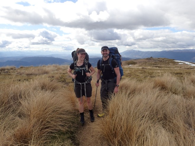
The newly weds heading up Robert Ridge
Day 1 – Up to Angelus Hut
We were finally parked at trailhead to Robert Ridge by 11:00am just outside St Anaud, after a detour past the DOC office to leave bags in safe storage and pick up hut tickets. Jude had broken her toe at Jen and Todd’s wedding, so they had headed off a little ahead of us all to get a headstart, and we planned to all meet for lunch at the shelter on Robert Ridge.
Heading up the switchbacks to Robert Ridge
The climb up from the carpark is a steady set up of uphill switchbacks, and we were all feeling the indulgences of the last week! After an hour or so, we spotted Jon and Jude, who’d already broken for lunch. They were happy to pack up and keep going with us all a little further, and we soon reached the shelter. After windy lunch, we continued along the ridgeline with eyes on the clouds around us.
Robert Ridge was a little scrambly at times, with the snow covering the path in places and we alternated between picking our way through the rocks and walking on the firm snow.
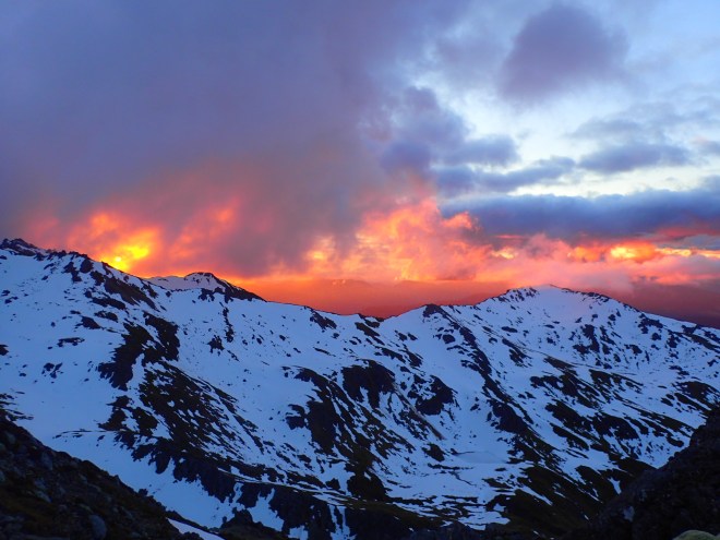
Before we knew it, the sky began to turn pink, and we became surrounded by the most majestic sunset over the mountains around us.
Sunset from Robert Ridge
By this stage, everyone had realised that Jonno’s predictions of how far the hut was weren’t to be trusted, so we kept walking with headlights as it grew dark around us, paying careful attention to the trail markers around us.
After controlled slides down a steep, snowed over hill, we arrived at Angelus Hut to find the fire going and another couple keeping Mike (who had beaten us there) company. It was Jude’s birthday, so as soon as we had changed clothes and gotten warm, we set to the business of celebrations, dinner, birthday cake and dutch stroopwafels – and a beautiful evening of laughing and swapping stories and philosophies of life, love and adventures.
Day 2 – Exploring the surrounds
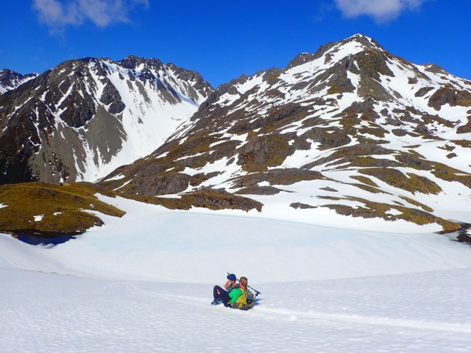
We woke up leisurely to some yoga and coffee, before strapping on our snowshoes and heading out to explore the area around Angelus Hut. Jon and Jude opted to stay behind to give Jude’s toe a rest, and waved us off as we headed southwards, up onto the ridge in front of the Hut.
Heading out to explore on snowhoes
We ascended and then traversed along below the ridgeline with ease, however some very steep – and sketchy – sections were required in order to reach the ridgeline proper above us – with Jonno and Todd out ahead cutting steps while the rest of us watched and followed.
Jonno cuts steps up to the ridgeline
We had an early lunch admiring the views, and Todd and Martina’s acro-yoga, before realising that we would actually have time to scramble up Mt Angelus, which was standing tall just behind us.
Todd and Martina showing us how it’s done
Tim and Martina decided to head back to the Hut a little earlier, and as they didn’t have snowshoes, took the fast route down the snow slopes and blazed off into the distance.
Tim and Martina take the fast route down
The rest of us scrambled around on the rocks to the base of the scree field leading up to the summit. We dropped our packs, and puffed our way up through the slippery scree. After about half an hour, we found ourselves on the snow with just a short burst up to reach the summit. We were well rewarded with panoramic views of the mountains around!
On the top of Mt Angelus
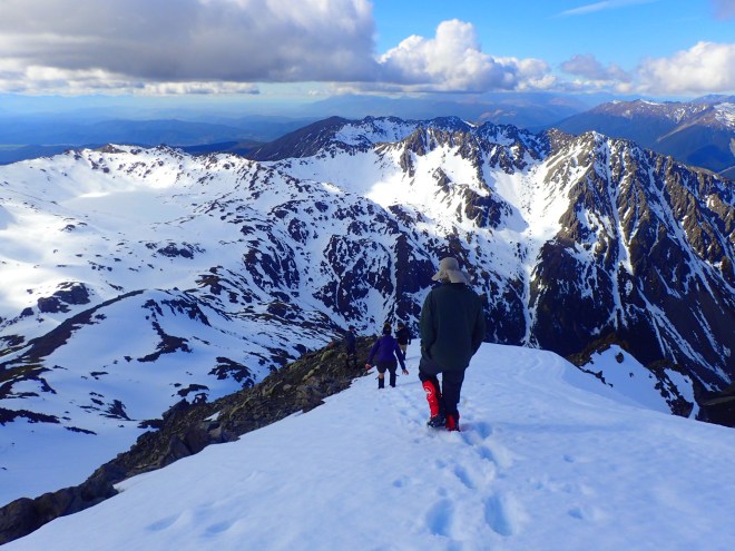
We scree-skiied our way back down to our packs, and then set off in Tim and Martina’s foot (and bum-sliding) prints. It was a relatively easy traverse around to the west and back towards the Hut, where Mike stopped for a swim in an open section of the otherwise frozen in lake – the rest of us watched and shivered in amazement (it turned out that Tim had done the same just a short time before!).
Heading down from Mt. Angelus
Day 3 – down to Sabine Hut
We woke up early keen to make a good start, hoping to reach Speargrass Hut so that our final day would be a short one.
We reached the treeline under the snow by lunchtime, and had a break to eat here fore heading on. Once within the trees, there was a lot of scrambling over fallen trees and wet roots, which slowed progress substantially. The clouds overhead were darkening, and by the time we reached Sabine Hut it was raining. We decided to pull up for the day and brave the notorious sandflies that plagued this particular hut – and all dived into Lake Rotoroa for a swim before hitting the tea and snacks.
Traversing around to the west towards Sabine Hut from Angelus Hut
Day 4 – fallen trees and missing water taxis
We woke early the next day, as we needed to cover a lot of ground in order to be sure to get back to our cars and to the DOC office before it shut to collect our bags.
We set off in the drizzling rain, and within metres were faced with a thick tangle of fallen trees. As we wove over, under and through the trees and thick undergrowth, slipping on wet roots and mud, we realised that this could take much, much longer than we had anticipated. Jude’s toe was certainly feeling the strain, and she and Jon decided to head back to the Hut to see if they could call a water taxi to come and collect them.
The rest of continued on with our slow progress, losing the trail at times, and were greatly relieved when around 1.5 hours out from the hut, the trail became clearer and we could stretch out our strides.
We continued on and crossed a swollen river with a variety of techniques, reaching Speargrass Hut for lunch. We realised that we were making good time despite the morning’s delay, and powered on in the afternoon to reach the carpark by 3pm. We picked up all the vans, and headed over to the DOC office to collect our bags – expecting to see Jon and Jude waiting there for us… but no luck!
After a few phone calls, the DOC officer informed us that someone had indeed tried to call the water taxi, but hadn’t been able to connect through. We realised then that Jon and Jude would likely try to walk out with Jude’s broken toe. They might make it to Speargrass Hut and stay overnight, or they might get all the way out that same day. With no way to contact them, all we could do was return their van to the trailhead, hike the keys for them, leave a note to let them know where we were and hope that all would work out!
Sure enough, we had all no sooner settled in to the Alpine Lodge and showered, when they walked through the door – having made excellent time with Jude powering on with her usual, indefatigable style! It was a great hike, with wonderful friends, and one we’d certainly recommend!
The Sierra High Route was first conceived by leading Californian climber and outdoorsman Steve Roper in 1977. His book – which we haven’t read, but probably should have – describes a route through the Sierra mountains that stays as high as possible, rarely dipping below 10,000 feet in elevation, while visiting some of the most spectacular, iconic settings of the high alpine regions of the Sierra Nevada mountain range.
The route consists of about 210 miles (340km) of on- and off-trail hiking, crossing 33 high alpine passes and running from north to south across the heart of the Sierras, through Sequoia-Kings Canyon National Park, John Muir Wilderness, Ansel Adams Wilderness, and Yosemite National Park.
It has been variously described as “brutal”, “the hardest hike in America”, “a remote trek and a route finder’s dream”, and “a rugged alternate to the John Muir Trail (JMT)”. As a result we had thought long and hard about this trip, and whether we should instead stick to the immensely popular, and well marked JMT. In the end, the SHR won out for two main reasons: challenge and solitude. Armed with a mapset and compass we set off with strong legs, an enthusiastic spirit…and heavy packs.
We’re pleased to report that we completed the route in 13 days, with one resupply along the way. Over the 340km route, we ascended over 18km, and the same again of descent. That’s a lot of up and down – the equivalent of climbing Mt. Everest from sea level twice – much of it off-trail and over talus and scree.
Day 0 – Roads End to Grouse Lake (nearly)
Most of today was spent racing towards our starting point, Roads End in Kings Canyon. Despite encountering a succession of ‘Sunday drivers’ and several road closures (to repair bushfire damage), Bryan, our Fresno-based driver, was doing everything in his power to deliver us to the Road’s End ranger station before it closed at the unusually early time of 3.30pm so that we could collect our permit.
We arrived at 3.20. Ranger Sailor scribbled some indecipherable information onto our permit, signed it and we were off. We immediately began slogging it up the Copper Creek trail – sweating under the weight of 8 days food (hopefully enough to get us to our resupply) as we clawed our way up 1,700 m of graveled elevation gain to reach our first evening’s camp just after dark, just shy of Grouse Lake.
Day 1 – Grouse Lake to Marion Lake
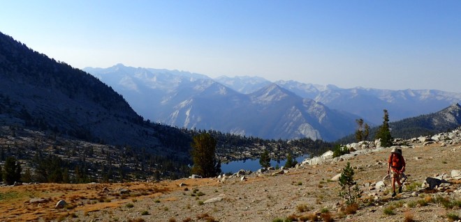
The day started well with a short hike to have breakfast overlooking Grouse Lake, followed by a couple of hours following vaguely forested trails into the more exposed rocky outcrops of the high Sierra.
By mid-morning our shoulders were aching, by mid-afternoon we were contemplating whether our insurance would cover knee replacements.
We followed our nose to Grouse Pass, Goat Crest Saddle and Gray Pass, which we managed without too much trouble. White Pass was a different matter. A long, steep ascent up a pine dotted mountainside, hopping across splashes of granite, took us several hours – and constant map checking – in the afternoon heat.
We weaved left and right as we slowly fought our way up the hill, that seemed relentless. Finally, near the top, we were rewarded with a view of the pass – no more than a mile away – and put our heads down to grind up to the top. Both of us had tired legs, but marched on thinking about the downhill on the other side – and deliberately not thinking about the several hours of daylight left that meant it was some time yet before we could kick out boots off for the day!
Cresting White Pass, our eyes ventured east – and not too far away we spied Red Pass. It was an enjoyable traverse of the rock slabs from White Pass to reach Red Pass, then, as dusk approached, a bone-rattling, knee-pounding descent to the turquoise of Marion Lake…
We found a good tent site just above the lake, set up camp in the fading twilight, and enjoyed our first taste of couscous, dried vegetable and TVP surprise – little did we know that both the dinner and the day was to become typical of the days that followed.
By the end of the day Jonno was spent. “That is the toughest day of hiking I’ve done in a long time”, he said – one day down, only two weeks to go…
Day 2 – Marion Lake to Lower Palisade Lake
We woke early, breakfasted and started the day with far more spring in our step than the previous evening. With the sun still hiding behind the morning cloud we navigated our way around Marion Lake and up the stepped slopes of Lake Basin toward Frozen Lake Pass.
A rare and much needed break in Lake Basin!
Locating Frozen Lake Pass was, for us, problematic. The terrain features didn’t marry with our map but we pressed on for 30 minutes regardless. We triple-checked our map and realised the error of our ways. Too far north and not far enough east. We scurried across a couple of gulleys and managed to regain the approach to the pass. We had lost an hour and we were both frustrated and annoyed. We needed a snack.
This was our first major DNF (Daily Navigational F…ailure). Similar such navigational hiccups were to become a feature of our first days on the trail and it wasn’t until day 7 that we were able to celebrate a daily where we had succeeded in getting the nav right for the entire day.
Jonno descending from Frozen Lake Pass
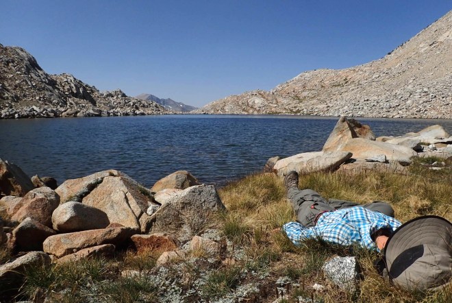
Eventually we crested the steep rock. The sketchy descent down scree and talus from Frozen Lake Pass met with its sphincter-tightening reputation, and lasted well over an hour – broken by a lunch and swim intermission at a small glacial-fed lake that gave the pass its name.
Jonno braves the water near the base of Frozen Lake Pass
By mid afternoon we had joined the John Muir Trail – a veritable superhighway – and were zig-zagging our way up the long switchbacks that led up to Mather Pass. After seeing nobody for the first couple of days on the High Route, we were a little overwhelmed to meet a dozen people in the first 30 minutes. The well-maintained trail up to Mather Pass, cut into the seemingly impossible face of the rock, was an engineering marvel – a series of long, low-angled switchbacks leading up through jumbled rock and scree to our second major pass of the day.
On our descent the storm clouds that had brewing all afternoon finally opened up. We continued walking for a couple of hours in the drizzly rain past numerous tents (their occupants firmly ensconced in book reading and tea drinking) until finally setting up camp alongside lower Palisade Lake. We had hoped to get over Cirque Pass that afternoon, but the rock looked to dangerous in the wet, so we agreed to head off early the next morning to try to make up time. Cirque Pass would again take us off trail, so while Angie cooked up couscous delight (again), Jonno scouted out a route up the rock face that stood impressively in front of us.
Looking back from the trail up to Mather Pass
The trail up to Mather Pass
Day 3 – Lower Palisade Lake to Head of Kings River
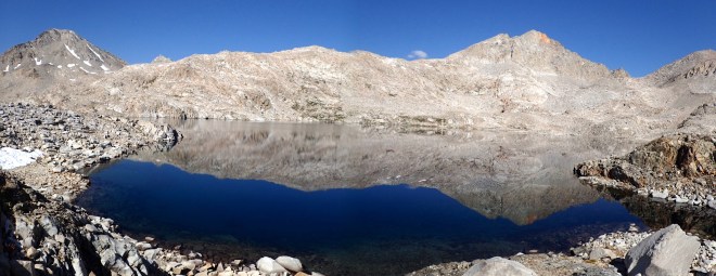
We woke and packed early, planning to breakfast after we had climbed up the steep rocky slabs that led up to our first objective of the day – Cirque Pass. We reached a plateau with gorgeous views back down to the Palisade lakes, and up to the rock cirque that still sat above us, after an hour. We breakfasted by a little lake (noting that this could have been a great campsite!), and tried to work out the route to the Pass above us, through the steep series of rock slabs at the head of a hanging valley. It was very picturesque, even in the overcast morning light.
Our breakfast spot, looking out over a little perched lake to the Palisade basin beneath
Jonno heading up towards Cirque Pass above
Soon we were scrambling up and over the rock slabs, with Angie scouting ahead on a potential route out to the far right. Unfortunately, she soon found herself stuck with a set of steep ledges and overhangs above her and no choice but to try to scramble back down, losing a lot of both energy and time. With a little more looking around, we found a few rock cairns, and managed to pull ourselves up to the pass with much relief.
From there we traversed across to Knapsack pass, and then dropped into the Dusy Basin from Knapsack Pass – it felt very remote. The terrain was the most rugged we had yet experienced, but the scale of the scenery was impressive… treeless, rock slabs and boulders hung from the jagged mountain ridges like an unkempt hipster’s beard. As far as the eye could see there was talus, talus and more talus…
Picking through talus
Talus fields stretching out ahead of us
En route towards Knapsack Pass
By late afternoon we had wandered down into a treed valley to join up with the Bishop Pass Trail. Again it began raining. We descended a steep, switchbacked trail past water streaming down giant slabs of rock to arrive back at the JMT.
We had hoped to meander up the LeConte Canyon and cross Muir Pass today, but the DNF and the rainy weather curtailed our plans somewhat. We ended up camping in a wet, snowy campsite a couple of hours below the pass – much to Angie’s relief, with her legs aching and feeling right at her physical limits. We passed a number of JMT thru-hikers who shared stories of their afternoon anguish up on the pass. Apparently where we had experienced a bucketful of rain they had experienced a gale, with a thunderstorm and hail thrown in. “Terrifying” was how one hiker described it.
As we settled into our dry sleeping bags that evening we felt exhausted – and lucky.
Day 4 – Head of Kings River to Upper Wahoo Lake
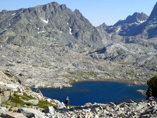
Waking early, we quickly ascended the trail to Muir Pass through the most spectacular basin of sapphire blue lakes, reflecting perfectly the surrounding mountains, which were to become a feature of the day.
Spectacular lakes en route up to Muir Pass
After a good snack break at the pass, we descended into Evolution Basin, the trail hugging the edge of a number of pristine alpine lakes – Wanda Lake, Sapphire Lake, and finally Evolution Lake. The sun was out and without a doubt it was the most incredible scenery we had witnessed so far.
We left the trail late in the morning to scramble up to Darwin Bench, aided by a few strategically placed rock cairns. We spent the following hours being frustrated by the navigational challenges imposed on us by the undulating terrain. We scrambled up, down and over endless trees, rock ledges, streams and thick brush, in contradiction to the notes we’d read that suggested the Bench provided an easy path. It was very challenging, physically and mentally. Eventually we broke out of the treeline to cross the swampy sections of a high plateau.
Along the JMT through Evolution Basin, before heading up to Darwin Bench
Suddenly, the skies opened yet again and we found ourselves in the midst of a hailstorm. The hail was fierce, stinging our eyes and exposed skin. We huddled behind a stand of pines until the storm abated. Once the hail had slowed, we continued our ascent of the valley toward a small groove in the fearsomely corrugated ridgeline, Snow Tongue Pass. The sun eventually broke its way through the cloud cover to shower us in late afternoon alpenglow.
At Snow Tongue Pass we stared down into the abyss below. It was an extremely steep descent ahead of us – real sphincter-clenching stuff. “Probably Type 3 fun”, Jonno offered in jest. Then, after a minute or two of descent, the hail started again. “ Let’s revise that to Unfun.”[1]
In between hail storms, Jonno picking his way down from Snow Tongue Pass
We slowly inched our way down the steep scree and loose talus, firmly thrusting our poles into any nooks and crannies we could find along the way. With the hail biting at us with every step, it was painfully slow going.We agreed on inventing new categories for describing the personality of the talus we encountered. ‘Friendly’ talus is large blocks firmly rooted in place, where one could hop from one rock to another without fear. “Unfriendly talus’ is the opposite – loose and unstable, often smaller, and ready to crush a limb at any moment.
By dusk we had picked our way down the car-sized rocks to Humphrey’s Basin and arrived at upper Wahoo Lake – with just enough moonlight for us to see each other we pitched the tent on the shore of the lake, before collapsing into bed absolutely exhausted.
Sunset over Wahoo Lake as we skirted the shores to find a campsite
Day 5 – Upper Wahoo Lake to BearPaw Lake
The following morning we again woke at dawn and started off straight away. It promised to be another big day, with several more passes and some significant changes in elevation.
More talus greeted us as we made our way to Piute Pass. From there we made our way past Tomahawk Lake and Mesa Lake, then scrambled up a ramped series of rock benches to Puppet Pass, where we met the first people we’d seen in a day or two. They were doing a day trip from their camp. We rock-hopped quickly past them on the descent, now used to traversing the (in this case friendly) talus.
A few hours later, scrambling down through forests of pine and mixed vegetation we joined the Pine Creek Pass Trail and descended into French Canyon, giant slabs of dolomite dominating the northern side of the valley.
We then scrambled northwards up a very steep trail that led through the forested dolomite slabs to Merriam Lake, continuing past the lake up a broad valley surrounded by jagged ridges of loose rock. Another steep scramble led us to La Salle Lake, and from there toward the impressive prominence of Feather Peak. It was tough work hiking up to Feather Pass amongst yet more haphazardly strewn talus – we celebrated the achievement with an early dinner at the Pass of soup, mashed potato and vegetables, and dark chocolate.
Following the watercourse up to Feather Pass
Dinner at Feather Pass
After gingerly descending from the pass on a giant field of talus we arrived at the damp, spongy shoreline of BearPaw Lake just on dusk. It had been yet another knee-grinding day and we were both relieved to tumble into our sleeping bags.
Camping on the spongy BearPaw Lake shore
Day 6 – BearPaw Lake to Laurel Lake
We passed another couple of campers and an avid fisherman early the following morning as we bounded down the valley. Unfortunately we bounded a bit too far. We missed a critical NE turnoff up a rocky gully to Black Bear Lake – only when we arrived at Big Bear Lake did we realize our error. Within 30 minutes we were back on course, the annoyance of yet another DNF subsiding rapidly with the onset of a hearty breakfast.
We traversed the rocky walls, slabs and blocks that surround White Bear, Brown Bear, and Teddy Bear lakes, slowly descending a vast valley under the watchful eye of the chiefly eminence of Granite Peak that led us toward Lake Italy. As Jonno was engaged in discussion with a solo hiker whilst re-filling his water bottle on the shore of Lake Italy, Angie led the way up a series of rocky, red slabs toward Gabbot Pass. The sun was out in force as we powered our way up and over the pass, the sweat cooling quickly on our bodies as we descended a steep pseudo-trail that dropped us into Mono Creek.
From Mono Creek we continued northward up a steep switch-backed trail to Laurel Lake, where we found a great lakeside campsite in an amphitheatre surrounded by serrated ridges of red, white and silver rock.
Day 7 – Laurel Lake to Deer Lakes
Within 30 minutes of leaving camp the following morning we had made our way up to Bighorn Pass, a steep scramble up rock and grass slopes. We had taken to selecting ‘green ramps’ as our way up steeper slopes and gullies – figuring that if the grass could grow there then we should be able to climb it.
Some complicated navigation – which we managed without error – brought us to Shout of Relief Pass.
Jumping for joy at Shout of Relief pass
Crossing the Silver Divide we descended into a basin of silvery lakes, before joining a use trail that allowed us to descend to Tully Hole and back up to the beautiful Lake Virginia where we lunched under a warm sun. A few other Pacific Crest Trail hikers had the same idea so we enjoyed a brief interlude chatting to them.
In the afternoon we followed an easy, well-maintained trail to the spectacular Duck Lake, then left the trail in a westerly direction to skirt along the edge of the Mammoth Crest, a ridge with a very steep drop-off to the NE.
After all the up and down our legs were extremely tired. We had planned to have dinner at Deer Lake and then continue on another hour, but halfway through our meal it began to rain again, and so we were both secretly relieved to set up camp beside the scenic Deer Lakes just as the fiery sun began to set.
Day 8 – Deer Lakes to Superior Lake
Skirting along the edge of the Mammoth Crest to Mammoth Pass the following morning was one of the highlights of the trip. The views opened up around us – we soon saw signs of the human sprawl from the Mammoth township. We skied down a near-vertical slope of dust to reach Mammoth Pass, then wandered through a forest of charred, post-apocalyptic-like tree stumps (the result of fires way back in 1992) toward our one and only food resupply point at Reds Meadow.
Never thought an ice-cream sandwich could taste so good
We stuffed our faces with ice cream, hamburgers, beer and chips at Red’s Meadow, had a much needed shower, washed our clothes and repacked, and listened to a number of PCT and JMT hikers regale us with their stories of how well they were managing (or not) on their respective trails. Around mid-afternoon we continued northward on a trail leading toward Superior Lake, dodging a sizeable contingent of tourists huddled around the Devils Postpile National Monument on the way.
Devil’s Postpile National Monument – naturally formed columnar basalt that creates these enormous, spectacular columns
Day 9 – Superior Lake to Thousand Island Lake
Early the following morning we met a father-son duo intending to complete a section of the SHR – this was their first off-trail section, so they were keen to set out with us. Together we began a very steep scramble up to Nancy Pass, through dense, unpleasant vegetation. Sweat ran into our scratches. Our colleagues laboured under the weight of their packs, so once the rest of the route to the Pass was clear, we pushed on without them as we were mindful of the distance we still had to cover that day. It was the first time we’d met anyone hiking the SHR in the same direction as us and it was noticeable just how much ‘route fitness’ we had acquired over the previous week.
The view from Nancy Pass was impressive and well worth the scramble up! We dropped down into the Minaret Basin, traversed a number of rock ledges, then climbed up to turquoise blue Minaret Lake. We met a number of other hikers on shorter trips, who encouraged us to continue onward to Cecile Lake and Iceberg Lake. This series of lakes was one of the scenic highlights of the route so far.
OLYMPUS DIGITAL CAMERA
OLYMPUS DIGITAL CAMERA
The afternoon was spent scrambling up and down passes, and immersing ourselves in the solitude of the valleys in between. We pushed past Lake Ediza and over Whitebark Pass, before dropping our jaws at the sight of Garnet Lake, closely followed by Thousand Island Lake, our campsite for the night.
Day 10 – Thousand Island Lake to Lyell Forks
Some very technical navigation took us to the first of the Twin Island Lakes. We scrambled along the ledges on the eastern side, after descending steeply from Glacier Lake. There was no semblance of a trail and the scrambling down the valley to Bench Canyon required some careful navigation and footwork.
Under a hot afternoon sun we scampered up past the pristine Blue Lake and Blue Lake Pass to join the Isberg Pass Trail, which took us through pine forest, finally descending to our day’s rest at a makeshift campsite near Lewis Creek.
Garnet Lake
Day 11 – Lyell Forks to Gaylor Lakes
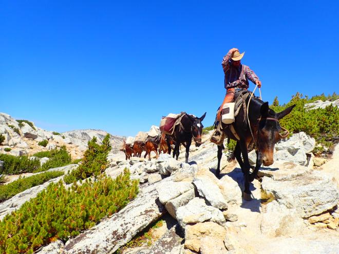
This was our easiest day of hiking – we covered about 30 miles on well-worn trails. A slow grind brought us to Vogelsang Pass where we passed a couple of cowboys languorously guiding some heavily laden horses up the trail.
Cowboys coming over Vogelsang Pass
We lunched and bathed at Vogelsang Lake before a long march took us to the well-known Tuolumne Meadows. Much to Angie’s disappointment we arrived a few minutes too late to catch the last bus to a café and shop a few miles down the road. Somewhat disheartened we settled for a riverside dinner of… couscous and vegetables (surprise!), before another couple of hours brought us to a mosquito-infested campsite near Gaylor lakes.
Day 12 – Gaylor Lakes to Shepherd Lake
The ruins at the Great Sierra Mine
The sky was clear as we began our day hiking past the ruins of the Great Sierra Mine and then over gentle terrain toward the Conness Lakes. We traversed various rock outcrops under a warm sun, then roller-coasted over one pass after another. We lunched alongside an unnamed alpine lake, then clambered up the ridge to the north. We looked west to see a band of mountaineers being trained in crevasse rescue techniques on the lower reaches of the Conness Glacier.
Nearly averted catastrophe: climbers attached by snow anchors, who were nearly wiped out by a falling boulder
Suddenly we heard loud cries of ‘ROCK!’. A giant block, perhaps the size of a small bus, had been dislodged by some other climbers further above and was pummelling down the steep glacier toward the trainee mountaineers. They were desperately straining to get out of the path of the falling slab, but were fastened to the spot by snow anchors they had hammered in for safety. We stood, absolutely horrified below, watching an absolutely disaster unfold above us as the climbers remained pinned to the spot, about to be wiped out.
Fortunately, just above the climbers, the rock collided with a pile of rocks and splintered, with the rock fragments coming to rest just metres short of the trainees. We were both quite shaken, although no doubt not nearly as much as the climbers who probably couldn’t believe they were still alive.
OLYMPUS DIGITAL CAMERA
OLYMPUS DIGITAL CAMERA
By this stage, the end of the SHR felt within our grasp, and our thoughts wandered more and more frequently towards showers, hot meals (that didn’t include couscous!) and a proper bed. But, to squish any hint of over-confidence, we soon encountered Sky Pilot Col. This high pass was undoubtedly the toughest we had to navigate and previous trip reports had described it as “dangerous”, “irresponsible” and “offensive” (this last being a description by Roper himself).
A faint use-trail led up through loose, dusty scree and over an interim pass consisting of what can best be described as rockfall – extremely loose rock clinging desperately to faces of a ridge. From there, the way ahead was very unclear. We could cross the scree basin ahead of us and try to ascend a wall of steep, loose scree ahead – or try to scale the (also) steep, but firmer rock to our left and see if we could traverse the ridge line around to the north where we thought the pass lay. We opted for the firmer rock, but soon realised the ridge was impassable, and hence soon found ourselves skirting around the rockface on some of the sketchiest terrain we’d covered to date. As we clambered over the steep ridgelines that ran down the face, we tried to keep focused on the way ahead and not to look down. Finally, we climbed over one last ridgeline, and found ourselves looking down a steep gully that we realised – with much relief – was the correct one.
Looking up at Sky Pilot Col – in retrospect, we should have headed directly across and up, rather than clambering around to the left.
But as it turned out, we hadn’t even done the hardest part yet! The talus we had to climb and skirt through was some of the loosest yet, and perhaps due to the near-accident we’d witnessed earlier in the day, we were a little more ‘on edge’ than usual. It was seriously heart-pumping stuff, requiring constant attention at every step. Jonno – who normally feels pretty confident on this kind of terrain – fell more than once and unleashed a torrent of abuse on the mountain while trying to regain his footing. After several hours of soul-depleting talus-hopping we finally reached Shepherd Lake, where we had dinner and set up camp as the sun set.
Day 13 – Shepherd Lake to Twin Lakes
This was to be our final day on the trail. Several grassed valleys contained a variety of lakes, streams and rocky sub-alpine passes, before we would finally arrive at Twin lakes, a welcoming site, a glistening blue gem set amongst the pines of the Hoover Wilderness. And cold beer.
First up we had to descend into Virginia Canyon, up the other side, and traverse the edge of Soldier Lake. A faint use trail helped us to find our way to Stanton Pass, where we cautiously made our way down the left hand side of steep rock slabs and scree. We then traversed the eastern flank of Spiller valley – giant rock ridges staring back at us – before grinding our way up to the gold, cream and brick-red rock of Horse Creek Pass.
After lunch we scrambled down faint, occasional paths – through heavy scrub in many places – before finally joining a well-travelled switchback trail for our last hour to the lakes. It is hard to describe just how elated we were to reach the end of this route – definitely one of the most challenging and rewarding that either of us have undertaken. Almost immediately we had forgotten that our legs and feet were aching, and we couldn’t stop grinning as we remembered the last 13 days with the breathtaking views, rare wilderness and spectacular challenges.
[1] As one blogger noted “Snow Tongue Pass would better be described as “Sketchy Ass Pass.” Rock falls were waiting with every step.”