
Our next adventure was into Wyoming’s Wind River Range. And what an adventure it was. We both agree that it was one of the best – if not the best – multi day hikes that either of us had ever done. The 80 miles of spectacularly beautiful alpine terrain that alternates between following existing trails and breaking out off-trail across unmarked terrain makes it challenging in terms of navigation and route finding, and so rewarding to feel like you’re really discovering this untouched wilderness. And it is peaceful – it is difficult to recall a place where solitude was more profoundly embodied.
Day 1 – Green River Lakes Trailhead to Peak Lake
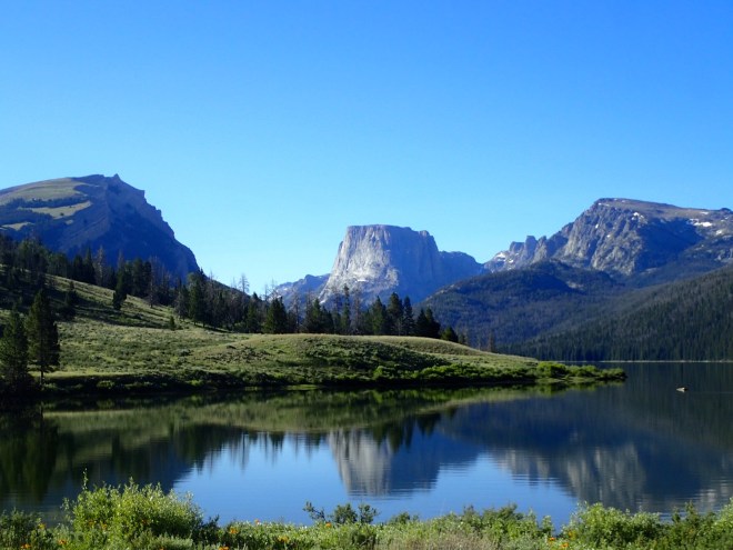
An hour’s drive along a 40-mile corrugated dirt road brought us to the appropriately, if not particularly imaginatively, named Green River Lakes trailhead. To the south, standing proud above the emerald lakes, is the imposing profile of the also very literally named Squaretop Mountain, which guided us for much of the first day as we sidled the lakes and valleys leading up to the high country.
The weather was brisk as we left the van and began our walk. In the first few hours we passed a few other hikers and fishermen returning after a night out in the woods. We also bumped into an English lady partway through hiking the Continental Divide Trail, and she regaled us with her account of the rain, hail and sleet she had endured whilst walking the previous day.
After spending the morning ambling along the eastern shore of the lakes and linking streams we began a steady, gradual ascent toward a basin at 10,000 feet. This was marked by stunning Vista Pass and indicated the start of the hard work – we would be hiking up and down mountains and passes for the next five days – all at an altitude of around 3000 metres above sea level and with a total elevation gain of about 6km.


We continued upward, making our way through forests dominated by lodgepole pine, whitebark pine, subalpine fir, and Engelmann spruce.
We had hoped to cover as much as 25 miles that first day to give us a headstart on our itinerary, which to be honest was perhaps overly ambitious, however by late afternoon we had covered only slightly more than 20 miles and our feet and legs were emphatically clear that this was enough. We found a good campsite just above the sapphire waters of Peak Lake. While Angie prepared what soon became a standard dinner of couscous, rehydrated veg and TVP, Jonno hunted out a suitable spot to hang our bear bag (although to be honest we were much more concerned about rodents and other critters trying to get at our food than bears). The sun stayed out until around 9pm, with the long days giving us a much-appreciated chance to relax and enjoy the last of the sunlight and warmth before we hit the tent.
Day 2 – Peak Lake to Indian Pass (almost)
The beginning of our second day presented the first serious challenge – the ascent and descent of a snow-covered pass called Knapsack Col, dropping into the picturesque Titcomb basin. After a few hours of steady climbing and reaching the picturesque pass, Angie donned crampons to manage the descent through the glacier on the other side, although even by 9am the snow had already softened and the going was easier than expected.


After descending the glacier to the Titcomb basin below, we spent the next few hours wandering down a rocky valley, past the azure Titcomb lakes – some surrounded by mosquitoes, some not.

After lunch – which an overly friendly marmot joined us for, we veered off to the east, heading gradually up a valley along a well-maintained trail to Indian Pass.
After a couple of hours walking on fairly good use trails, we arrived at what we thought was Indian Pass. We sat and pored over the maps, trying to locate our next objective – Alpine Pass – however try as we might, we just couldn’t quite correlate the map and notes with what we could see around us.

The route description was consistent with a few of the features we saw before us, but not all. We could find some reasonable explanations for the differences – extra snowcover due to hiking so early in the summer, slight differences in the compass bearings due to magnetic variation, and possibly small errors by the author of the notes. We scouted around to see if we had possibly landed in the wrong location, but eventually decided that we must have been correct – and that Alpine Pass was the obvious pass in front of us.
For the next hour and a half, we gingerly ascended a field of large, loose talus and snow to an alpine pass and around a stunning, temporary lake sitting deep in a hole within the glacier to the east. No sooner had we arrived at ‘Alpine Pass’, than we could plainly see the error of our ways. The landscape below did not match at all with our map, and as we looked back from where we’d come, the real Indian Pass now obviously lay slightly to the north of where we had been. The sun was now hovering behind the mountains to our west and we didn’t have time to retrace our steps, so we decided to make camp on the snow at the base of Knifepoint Mountain, and tackle the ‘proper’ Indian and Alpine passes early the following morning. It was a very cold night.


Day 3 – Indian Pass to Camp Lake (sort of)
We rose early the next morning and immediately began climbing the snow up to Indian Pass, where we could see the sun warming the rocks. By 8am, we were breakfasting on the pass, thawing ourselves out, and feeling glad to have rejoined the route. Under what was now a scorching sun, we traversed the Knifepoint Glacier that lay on the other side of Indian Pass with ease before clawing our way up the steep snow slope to the proper ‘alpine pass’. The views down the valley were breathtaking. The upper alpine lake was half iced-up, the remainder was a deep bottle blue. We could have sat there for hours. Finally, we scrambled down the snow and large talus that dominated the southern flank, and enjoyed lunch on a small rock outcrop next to the frozen lake-edge.


As promised in the route description, this was to be our most challenging day navigationally – and given our experience of the previous day, we were constantly recalibrating our position with the map and mountain features. Thankfully the weather was beautiful and so long as we stayed above the treeline we were able to see the way ahead. We sidled three long lakes, then skirted along the base of some cliffs to follow a small stream to another side lake. In this side valley the wildflowers were in full bloom everywhere. We crested a high alpine plateau, containing yet more water, before dropping down into a pine tree-filled valley way below. The remnants of a trail appeared before we us and we followed the trail to a grassy knoll near to Camp Lake. The mosquitoes were voracious and we wasted no time in dining before hopping into our tent.
Day 4 – Camp Lake to Halls Lake
An hour’s scramble on a half-visible trail took us to a hanging lake where we enjoyed breakfast with the early morning sun at our backs.
The terrain became easier to walk through, but the navigational challenges still kept us on our toes. We dropped into a valley of pine forest and green grass.
In the afternoon the wind picked up and we hastened through the swampy terrain under a blanket of broody clouds.
Rock cairns led the way to the southern shore of Halls Lake.
Day 5 – Halls Lake to Shadow Lake (almost)

Thanks to a cold snap, this proved to be our toughest day. We woke up nearly frozen after a heavy overnight frost, and the morning consisted mostly of being blown around by the strong wind from the SW. It was bitterly cold – Angie’s hands inside her gloves had turned white and without gloves I had to resort to wearing my spare socks on my hands as mittens. The sky remained overcast until early afternoon, and the mountains remained ominously shrouded in thick grey cloud. It would not be a good place to lose your way.
For much of the morning we were plodding uphill, navigating off-trail toward the jagged nose of Pronghorn Peak whilst battling a strong headwind. We kept our heads down and focused on plodding forward, stopping only to read the map and have a moment of celebration when we reached the right pass.

After that we had to navigate our way off trail around Mount Bonneville and Raid Peak. The afternoon was completely off marked trails as we hopped across the large talus field that marked the ridgeline just below Raid Peak. On the far side of the pass, we crossed into the East Fork River valley and chatted briefly with a handful of outdoor leadership students – on their 26th consecutive day in the Wind River wilderness! Despite their tales of braving sleet, snow and hail storms they didn’t look as washed out and weather-beaten as one might expect – we were both thoroughly impressed! We walked quickly past Pyramid Lake where a faint trail appeared – we followed it to Washakie Creek and then to a broad meadow where we set up camp, with a small fire, just as the sun began to set.
Day 6 – Shadow Lake to Big Sandy
We awoke to another crisp morning. The sun inched its way above the high peaks to the east of us as we packed up and began a gentle stroll up the valley toward Shadow Lake and the lakes beyond. We then followed a series of rock cairns up toward the highest of the valleys’ alpine lakes: Texas Lake. From the lake a steep scramble up scree, talus and snow led us to Texas Pass.


Cresting the pass we were immediately humbled by the immensity of the Cirque of the Towers. This beautiful and famed cirque of granite spires includes mountains with such names as Warrior Peak, the Shark’s Nose and the Wolf’s Head – the highest being Lizard Head Peak, and most being very popular amongst rock climbers for some epic, multi-pitch routes.
A steep trail down from the pass led through pine forest and across numerous streams to Lonesome Lake, and from there we hiked up to the final pass – curiously named Jackass pass – for an enjoyable lunch on the rim of the other side of the cirque, sheltering from the wind behind a rock and enjoying the views to the north under a bluebird sky. A bird of prey, a falcon perhaps, circled the sky far above us.
Our final afternoon involved walking down the Big Sandy river valley – where we encountered dozens of people on their way to camp on the shores of one of the giant lakes. It was such pleasant walking, alternating between lake shores and forest trails, and a good way to ease the legs out after the previous 5 days.
